Plan Framework and Implementation Priorities
Mobility
The map below highlights the Mobility Framework identified for the Port San Antonio Area Regional Center Area. Scroll down to learn more about the vision for Mobility in the Plan Area.
To provide specific feedback on the map, please click and drag a box on that location of the map and fill out the comment box. We would love to hear more from you!
You can also visit the bottom of the page to leave additional feedback.
Background and Vision
In 2016 the City of San Antonio adopted the SA Tomorrow Multimodal Transportation Plan, to make our city’s transportation system “sustainable, safe, convenient, efficient, and inclusive of all modes.” The plan adopted by City Council established “a shift in focus from moving vehicles to moving people,” in order to manage traffic congestion and improve transportation choices. The plan identified two primary and interdependent methods for managing future traffic congestion:
- Develop a land use pattern and policy to promote and facilitate the ease of and improved access to local trips.
- Encourage more transportation options beyond personal vehicles for people to commute to the Regional Center.
The SA Tomorrow Multimodal Transportation Plan acknowledged that we cannot build our way out of congestion by continuously adding additional lanes and that the Comprehensive Plan, and associated land use plans, are a primary opportunity to improve mobility in San Antonio. By welcoming more people to live, work and play in urban centers, regional centers, and transit corridors, we can shorten trip lengths, offer more transportation choices, and improve quality of life.
The combined costs of housing and transportation are often a large portion of a household’s budget, with experts recommending the combined total should not be more than 45% of household income. In the Greater San Antonio Region that total on average is 53%. Walkable communities that provide increased transit options and have less dependency on automobiles can reduce the household transportation costs for the average person. If people have alternatives to driving that are convenient and safe, transportation costs can be stable even when gas prices rise. As some people choose to go to their destination on foot, bicycle, or transit, the number of cars on the road will be minimized. This will reduce traffic delays for those people that choose to drive.
<!– <div class='image right third'> </div>
Due to the presence of --> Lackland Air Force Base and Port San Antonio, which was previously Kelly Air Force Base, the Port San Antonio Area Regional Center has been an employment hub for the Greater San Antonio Region for over a century. Kelly Air Force Base was established in 1917 as an aviation training facility and in 1941 construction began to expand the base. This expansion eventually became a separate entity from Kelly Air Force Base and is today known as Lackland Air Force Base. In the 1940s through the 1970s, residential development near the air force bases primarily consisted of the base workforce. Kelly Air Force Base was decommissioned in 2001 and is now known as Port San Antonio. Today Port San Antonio is a significant freight hub and growing employer in southwest San Antonio. The Port San Antonio Area Regional Center, referred to as the Port San Antonio Area, incorporates this continued military presence with a dynamic technology and innovation campus with plans for an e-sports arena to further establish Port San Antonio as a destination specializing in innovation and technology. This area also still contains many of the residential neighborhoods, mostly consisting of single-family homes, that historically housed the Kelly and Lackland Air Force Base workforce.
With a focus on cybersecurity, aerospace, manufacturing, and incubating innovation in Port San Antonio, this Regional Center is poised to become a major employment center beyond its already large contribution to current employment opportunities. The mobility vision for the Port San Antonio Area focuses on linking this growing employment center with its surrounding neighborhoods and increasingly using transit to transport Port San Antonio Area employees that live beyond the Regional Center plan area. Although the transit routes focusing on West Military Drive are already well established and productive, access to transit will be key to this mobility vision. There will also be a particular focus on improving sidewalk quality and connectivity as a prime factor in providing access to transit. Pedestrian and bicycling infrastructure can support trips within or beyond the Port San Antonio Area. Existing right-of-way provides ample opportunities for building additional cycling and pedestrian infrastructure and connectivity to any new rights-of-way in future development of currently vacant or underutilized land.
Port San Antonio Area Regional Center’s Mobility Needs
Investments in transportation improvements are continuously made to move large volumes of freight efficiently, link neighborhood development to growing employment opportunities, and provide adequate transit routes that connect to areas outside the Regional Center. Growing populations demand that streets not only carry people, goods and services, but that they also serve as playgrounds, parks, and public spaces. Key mobility needs identified in this Regional Center include the following:
- Balancing mobility and character throughout mixed-use corridors and high functioning arterials;
- Ensuring quality of neighborhood connectivity and sidewalks and
quality of access to transit, parks, jobs;
- Supporting high capacity transit and using transit as a catalyst for economic development within the region; and
- Providing cycling and trail infrastructure that takes advantage of existing right-of-way.
To address the transportation needs in the Port San Antonio Area Regional Center, a set of high-level street classification recommendations have been developed to guide decision making. Recommendations include modal and intersection priorities, shown in the Mobility Framework map (Figure ##). Street type and use recommendations are shown in the Street Types map (Figure ##). These mobility recommendations will be further refined in a coordinated manner with the City’s Public Works Department and other relevant partners such as Texas Department of Transportation (TxDOT), VIA Metropolitan Transit (VIA), and the Alamo Area Metropolitan Planning Organization (AAMPO).
Port San Antonio Area Regional Center Mobility Framework
The Mobility Framework lays out the vision for accommodating the constantly expanding mobility needs of the Port San Antonio Area Regional Center. Below are guiding principles that will help ensure a mobility network that is safe and inviting for people walking, shopping, parking, and driving in the Regional Center.
Modal Priority Corridors
Streets play a multifaceted role in the plan area, serving both as arteries for traffic and as public spaces. Changes to street design can achieve the mobility vision of the Regional Center. The modal priority corridors reflect the vision for how motorists, bicyclists, transit users, and pedestrians will interact with key corridors throughout the area. Modal priority corridors guide design treatments of a particular mode. A modal priority corridor does not exclude other users but helps guide tradeoff decisions during the design of a specific street.
Automobile
Automobile corridors are envisioned to support high levels of motor vehicle travel daily. These corridors are often interstates, highways, arterials, and other primary roadways which provide connections to major destinations and link the Regional Center to other parts of the city. Significant automobile corridors in the Port San Antonio Area Regional Center include, but are not limited to, Loop 410, Covel Road, and West Military Drive. Automobile corridor improvements focus on relieving traffic congestion and enhanced roadway design to increase the safety of motor vehicle travel.
Freight
Freight corridors are envisioned to support the ability to move high levels of goods by freight trucks that will travel between industrial or commercial areas and major destinations. Growdon Road, Berman Road, Clarence Tinker Drive, and General Hudnell Drive are freight corridors in the Port San Antonio Area Regional Center due to their proximity to industrial areas and major rail lines and their connections to SW Military Drive, US 90, and Hwy 151.
Bicycles
Bicycle corridors are envisioned to provide convenient, safe, and comfortable biking options for all ages and abilities. An integrated network of bicycle routes along with well-designed streets in key activity areas aim to fill the gaps in the multimodal system. The mobility framework focuses on completing the bicycle network and recommends new connections to directly access trails and other amenities. Bicycles priority corridors in the Port San Antonio Area Regional Center are Five Palms Drive, which provides a connection from Lackland Airforce Base to adjacent areas that have a future land use designation of mixed-use, and along the Loop 410 access road, if a separated bike lane could be accommodated, to connect to Stablewood Farms Park.
Transit/Pedestrian
Transit and pedestrian corridors are envisioned to provide the community with easy, reliable, and congestion-proof choices for traveling to and from work, school, and key destinations. Streets, intersections, and traffic signals greatly influence transit service reliability and the passenger’s transit experience. Providing streets that enable reliable and frequent transit service and a walkable environment allows users to choose travel options besides driving – potentially alleviating the primary cause of congestion. As demand on public transit increases, improvements such as dedicated transit lanes, signal timing, and operational improvements along frequently used routes can keep transit vehicles moving regardless of traffic. Transit/Pedestrian priority corridors in the Port San Antonio Area Regional Center include Medina Base Road, Springvale Drive, Cupples Road, and West Thompson Place.
Multi-Use Trail
Multi-use trail corridors are envisioned to provide continuous arteries of separated pedestrian and bicycle facilities that connect numerous destinations, parks, retail and commercial development, schools, libraries, and residential areas. A multi-use trail provides access points to regional amenities and improves connections for people walking, or bicycling. There is potential to develop multi-use trail pathways providing east-west connections along US 90 with access to north-south connections along SW 36th Street, West Military Drive, and Medina Base Road.
Balanced/Multimodal
Balanced and multimodal corridors are envisioned as “Complete Streets”, with a street design that considers all users and accommodates all ages and abilities including children, older adults, and persons with disabilities. These corridors balance the priorities of multiple modes and require community conversations and case-by-case consideration to best align design with the community’s vision. The function of the road, level of traffic by mode, and adjacent land use and intensity will help determine the road type and design features. As the Port San Antonio Area Regional Center continues to grow in terms of employees, residents, and commercial services, proposed balanced and multimodal design treatments for Valley Hi Drive, Old Pearsall Road, SW 36th Street, General McMullen Drive, Billy Mitchell Boulevard, and Quintana Road should be prioritized to meet growth demands.
Pedestrian
Pedestrian corridors are envisioned as comfortable and safe pathways for residents connecting residential areas to amenities including transit stops, commercial development, parks, schools, and restaurants. Ray Ellison Boulevard and Springvale Drive south of Valley Hi Drive have been identified as priority pedestrian corridors within the Regional Center. Pedestrian needs and enhancements often include adding lighting, landscaping, buffered sidewalks, and connected crosswalks and pathways. These additions will increase the overall feeling of safety for all users and will encourage pedestrian travel to and from residential areas to commercial areas.
Pedestrian Priority Zones
Pedestrian priority zones refer to specific nodes that accommodate significant volumes of pedestrian activity. These priority zones aim to create high-quality street-level experiences to enhance the economic strength of commercial and mixed-use districts. These areas include large sidewalks, safe and balanced intersections, ample crossing opportunities and design characteristics focused on keeping pedestrians safe.
Community members identified the need to make Valley Hi Drive and Springvale Drive more pedestrian-friendly by ensuring these streets have adequate lighting and are redesigned to be ADA compliant. In addition to the Springvale Neighborhood, other pedestrian priority zones were identified on the eastern end of Old Pearsall Road near Pearsall Park and in the Thompson Neighborhood Association community.
Intersection / Crossing Enhancements
Intersection and crossing enhancements are envisioned as intuitive and predictable crossings for all users. Enhancement locations are identified where crossing is considered as a priority and pedestrians, motorists, and bicyclists share space. Whether signalized or un-signalized, crossings with a high level of multimodal activity including pedestrians, bicycles, and motor vehicles, will facilitate predictability for all users. Intersection enhancements include lowering motor vehicle travel speeds and ensuring high pedestrian visibility. Priority intersection and crossing enhancement locations are identified where complex movements occur and potential conflicts between pedestrians, bicycles and drivers exist.
Mobility Hubs
Mobility hubs are envisioned as scalable nodes of mobility options, such as frequent transit, shared rides, bicycling, and micro-mobility. These areas converge multimodal access and connectivity with adequate lighting, shelters, benches, real-time information, accessible sidewalks, and pedestrian crossings. A mobility hub is identified at the existing Kel-Lac Transit Center and a future mobility hub is identified around the intersection of 36th Street and Billy Mitchell Boulevard.
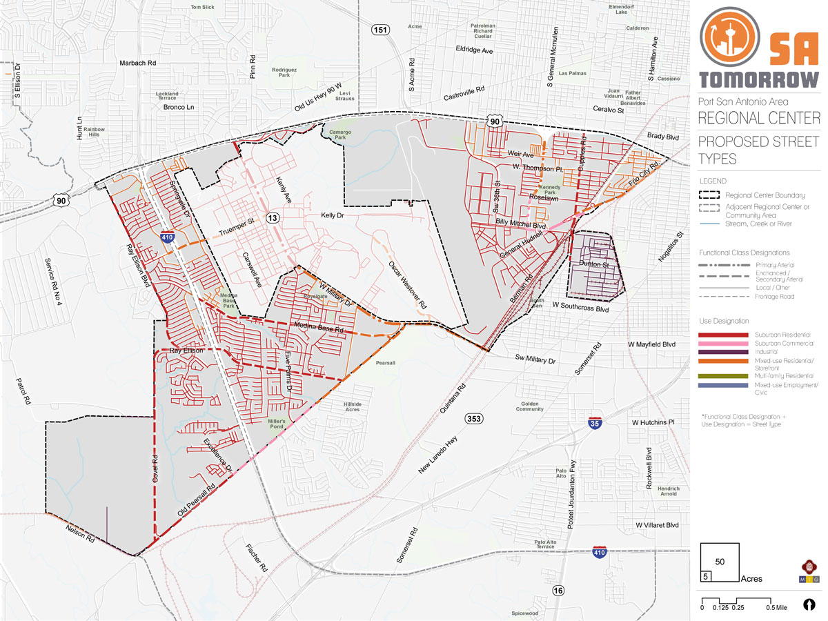
Port San Antonio Area Regional Center Street Types
As communities evolve and grow, so do the demands on the mobility system. The location and type of growth in an area or along a corridor help determine the demand on the transportation network and the viability of various transportation options. This interdependence makes it crucial to plan for transportation and land use collectively. Streets are organized not only by role and function but also by the character and surrounding context.
Land uses encouraging mixed-uses and higher density developments on major roadways will lead to additional pedestrians, bicyclists, transit riders, cars, and freight delivery trucks of various sizes. Future land use also influences other factors, such as drop-off delivery zones, shared mobility hubs, and walkability. The map below shows the interactions between future land use and transportation plans. The street type classifications integrate transportation and land use, to guide context-sensitive mobility solutions. Figure # shows how street type classifications were assigned based on transportation and land use.
[See Figure 7 – Street Types Map]
Relationship between the Street and Buildings
Safe and vibrant streetscapes depend on how buildings integrate with surrounding sidewalks. Minimizing building setbacks, the distance between a building and the street, is key for creating a walkable environment. Buildings that meet the sidewalk directly connect pedestrians to destinations and create an enlivened urban space with opportunities to activate ground-floor uses and provide shopping or entertainment offerings. The close proximity of buildings to the street also creates a more inviting environment for pedestrians and gives the sense that pedestrians are prioritized in the environment and were considered during the planning and development process prior to the buildings being constructed.
Smaller setbacks are characteristic of Mixed-Use Local, or Urban/Suburban Local street typologies, which prioritize pedestrian-oriented design. Meanwhile, larger setbacks that can accommodate front-end parking, are more characteristic of secondary arterials (whether suburban, industrial, mixed-use or urban). Primary arterials are designed to move vehicles and may require large setback minimums to accommodate additional parking.
Vehicle Speeds
A successful street hierarchy will align travel speeds with street usages and will decrease speeds accordingly by roadway function. While major regional roads may require higher speeds to accommodate larger volume and heavy traffic flows, most smaller roadways serve lower volumes of vehicles. On these roads, lower speeds ensure a safer environment for people and vehicles alike.
Street typologies that focus on moving vehicles, such as Suburban Commercial, Residential, or Industrial Super and Primary Arterials, will feature higher speeds. However, typologies that focus on people and places, such as Mixed-Use, Multi-family, Urban/Suburban Local Roads and Secondary Arterials, will feature lower speed limits to create increased road safety for both people and vehicles.
Parking
Parking provides access to residential, work, retail options, or entertainment. Cars searching for parking create serious traffic and safety challenges. Incorporating safe street design elements, such as buffering between bike lanes and traffic, can create a safer environment on and around streets.
Street types that emphasize people and places, such as those with Mixed-use or Multi-family contexts will restrict the supply of parking overall. Restricting space allocated for parking allows for more active uses, denser environments, and connectivity for pedestrians and cyclists. Meanwhile, intermediary street typologies that support vehicles as well as people and places will likely offer some on-street parking, in addition to smaller on-site lots. Conversely, Suburban Contexts or Super and Primary Arterials may forgo on-street parking altogether, favoring large surface lots and structures.
Curb Access
A space between the curb and the travel lanes provide an opportunity to serve many uses such as driveways, bus lanes, cycle tracks, on-street parking, bicycle parking, freight drop-off delivery zones, or shared mobility hubs. This flexible space between the curb and the street travel lanes can be converted based on demand and play a role in street activation. The design of the curb influences how cars and people enter and exit work, residential, and retail environments.
Addressing areas where traffic and turning patterns increase the risk of accidents will reduce conflicts between driveway traffic and pedestrians and will improve roadway safety.
Suburban Commercial contexts and Super or Primary Arterials will focus on the ease of ingress and egress for vehicles, while Mixed-Use or Local street typologies focused on moving people will emphasize how vehicle access can coexist with safe, walkable environments.
Lane Width
Lane width determines how space is allocated for motorists, buses, trucks, bikes, and parked cars. Streets often dedicate space for bike lanes, parking, safety islands, and travel lanes. The lane width will vary based on the surrounding context and modal priority. For example, transit, freight and emergency response vehicles require wider travel lanes, thus modal priorities need to be considered when determining the appropriate lane widths for roadways.
Wider lane widths are designed to move vehicles in high-speed environments. A Suburban Primary Arterial will be wide enough to efficiently move passengers through residential and commercial environments, while Mixed-Use Local or Suburban Local environments have narrow lanes to reduce crossing distances for pedestrians and to promote slower driving speeds, which helps improve pedestrian safety.
Port San Antonio Area Regional Center Mobility Framework
The Mobility Framework lays out the vision for accommodating the constantly expanding mobility needs of the Port San Antonio Area Regional Center. Below are guiding principles that will help ensure a mobility network that is safe and inviting for people walking, shopping, parkingspan, and driving in the Regional Center.
Recommendation #1
Continue implementing the San Antonio Vision Zero Action Plan.The City of San Antonio’s Vision Zero initiative aims to achieve zero fatalities on the community’s roadways and improve roadway safety for all users, whether driving, bicycling, or walking. The Vision Zero initiative evaluates and makes recommendations to improve safety in Severe Pedestrian Injury Areas (SPIAs), locations where two or more crashes close together have resulted in severe pedestrian injuries. Potential tools for improving pedestrian safety in SPIAs include Leading Pedestrian Intervals, Medians, and Pedestrian Crossing Islands based upon analysis of the unique factors that contribute to crashes in each location and depending upon the results of engineering assessments. Another approach to improve safety involves dedicating more space in the roadway to bicyclists and pedestrians. From new ways to protect bicycle lanes with separated barriers such as bollards, to landscaping and planters and raised medians, San Antonio has many available tools to improve pedestrian and bicycle safety. The City of San Antonio Vision Zero Action Plan lists additional tools for improving pedestrian and bicycle safety.
The Port San Antonio Area Regional Center has a wealth of opportunities for improving transportation and safety, such as improving crossings and investing in Complete Streets. In particular, the 2018 San Antonio Severe Pedestrian Injury Areas Report (pages 33-34) identifies SPIAs within the Regional Center that should be priorities for study and investment, including Old Pearsall Road from Loop 410 to War Cloud Street (from previous 2011-2015 SPIA) and Cupples Road from Menefee Boulevard to Kirk Place (from the 2014-2018 SPIA). See Figure # - SPIAs Map.
Additional analysis of pedestrian, bicycle, and vehicle crash data (beyond data and information from the SPIA report), along with community input, also identified additional points of conflict between people and vehicles that should be studied for future improvements. Major highways, such as US 90 and Loop 410 and their associated frontage roads, create barriers for many pedestrians and bicyclists. The unwelcoming environment of fast speeds and limited amenities hinders travel options for those walking or bicycling. Major roadways, like Old Pearsall Road and West Military Drive, have insufficient accommodations and less than ideal conditions for pedestrians and bicycles to travel on and safely cross. Numerous driveways create many potential conflict points between automobiles, pedestrians, and bicycles. Employing strategies to reduce these points of conflict can increase safety in the Regional Center.
Recommendation #2
Complete the multimodal mobility network and establish new connections through partnerships.Recommendation #3
Manage transportation demand by creating walkable places and supporting efficient transit operations through targeted interventions.Recommendation #4
Support VIA Metropolitan Transit Advanced Rapid Transit Corridor service by prioritizing transit-supportive policies and infrastructure near transit stations.Port San Antonio Area Regional Center Mobility Framework
The Mobility Framework lays out the vision for accommodating the constantly expanding mobility needs of the Port San Antonio Area Regional Center. Below are guiding principles that will help ensure a mobility network that is safe and inviting for people walking, shopping, parkingspan, and driving in the Regional Center.
Modal Priority Corridors
Streets play a multifaceted role in the plan area, serving both as arteries for traffic and as public spaces. Changes to street design can achieve the mobility vision of the Regional Center. The modal priority corridors reflect the vision for how motorists, bicyclists, transit users, and pedestrians will interact with key corridors throughout the area. Modal priority corridors guide design treatments of a particular mode. A modal priority corridor does not exclude other users but helps guide tradeoff decisions during the design of a specific street.
Automobile
Automobile corridors are envisioned to support high levels of motor vehicle travel daily. These corridors are often interstates, highways, arterials, and other primary roadways which provide connections to major destinations and link the Regional Center to other parts of the city. Significant automobile corridors in the Port San Antonio Area Regional Center include, but are not limited to, Loop 410, Covel Road, and West Military Drive. Automobile corridor improvements focus on relieving traffic congestion and enhanced roadway design to increase the safety of motor vehicle travel.
Freight
Freight corridors are envisioned to support the ability to move high levels of goods by freight trucks that will travel between industrial or commercial areas and major destinations. Growdon Road, Berman Road, Clarence Tinker Drive, and General Hudnell Drive are freight corridors in the Port San Antonio Area Regional Center due to their proximity to industrial areas and major rail lines and their connections to SW Military Drive, US 90, and Hwy 151.
Bicycles
Bicycle corridors are envisioned to provide convenient, safe, and comfortable biking options for all ages and abilities. An integrated network of bicycle routes along with well-designed streets in key activity areas aim to fill the gaps in the multimodal system. The mobility framework focuses on completing the bicycle network and recommends new connections to directly access trails and other amenities. Bicycles priority corridors in the Port San Antonio Area Regional Center are Five Palms Drive, which provides a connection from Lackland Airforce Base to adjacent areas that have a future land use designation of mixed-use, and along the Loop 410 access road, if a separated bike lane could be accommodated, to connect to Stablewood Farms Park.
Transit/Pedestrian
Transit and pedestrian corridors are envisioned to provide the community with easy, reliable, and congestion-proof choices for traveling to and from work, school, and key destinations. Streets, intersections, and traffic signals greatly influence transit service reliability and the passenger’s transit experience. Providing streets that enable reliable and frequent transit service and a walkable environment allows users to choose travel options besides driving – potentially alleviating the primary cause of congestion. As demand on public transit increases, improvements such as dedicated transit lanes, signal timing, and operational improvements along frequently used routes can keep transit vehicles moving regardless of traffic. Transit/Pedestrian priority corridors in the Port San Antonio Area Regional Center include Medina Base Road, Springvale Drive, Cupples Road, and West Thompson Place.
Multi-Use Trail
Multi-use trail corridors are envisioned to provide continuous arteries of separated pedestrian and bicycle facilities that connect numerous destinations, parks, retail and commercial development, schools, libraries, and residential areas. A multi-use trail provides access points to regional amenities and improves connections for people walking, or bicycling. There is potential to develop multi-use trail pathways providing east-west connections along US 90 with access to north-south connections along SW 36th Street, West Military Drive, and Medina Base Road.
Balanced/Multimodal
Balanced and multimodal corridors are envisioned as “Complete Streets”, with a street design that considers all users and accommodates all ages and abilities including children, older adults, and persons with disabilities. These corridors balance the priorities of multiple modes and require community conversations and case-by-case consideration to best align design with the community’s vision. The function of the road, level of traffic by mode, and adjacent land use and intensity will help determine the road type and design features. As the Port San Antonio Area Regional Center continues to grow in terms of employees, residents, and commercial services, proposed balanced and multimodal design treatments for Valley Hi Drive, Old Pearsall Road, SW 36th Street, General McMullen Drive, Billy Mitchell Boulevard, and Quintana Road should be prioritized to meet growth demands.
Pedestrian
Pedestrian corridors are envisioned as comfortable and safe pathways for residents connecting residential areas to amenities including transit stops, commercial development, parks, schools, and restaurants. Ray Ellison Boulevard and Springvale Drive south of Valley Hi Drive have been identified as priority pedestrian corridors within the Regional Center. Pedestrian needs and enhancements often include adding lighting, landscaping, buffered sidewalks, and connected crosswalks and pathways. These additions will increase the overall feeling of safety for all users and will encourage pedestrian travel to and from residential areas to commercial areas.
Pedestrian Priority Zones
Pedestrian priority zones refer to specific nodes that accommodate significant volumes of pedestrian activity. These priority zones aim to create high-quality street-level experiences to enhance the economic strength of commercial and mixed-use districts. These areas include large sidewalks, safe and balanced intersections, ample crossing opportunities and design characteristics focused on keeping pedestrians safe.
Community members identified the need to make Valley Hi Drive and Springvale Drive more pedestrian-friendly by ensuring these streets have adequate lighting and are redesigned to be ADA compliant. In addition to the Springvale Neighborhood, other pedestrian priority zones were identified on the eastern end of Old Pearsall Road near Pearsall Park and in the Thompson Neighborhood Association community.
Intersection/Crossing Enhancements
Intersection and crossing enhancements are envisioned as intuitive and predictable crossings for all users. Enhancement locations are identified where crossing is considered as a priority and pedestrians, motorists, and bicyclists share space. Whether signalized or un-signalized, crossings with a high level of multimodal activity including pedestrians, bicycles, and motor vehicles, will facilitate predictability for all users. Intersection enhancements include lowering motor vehicle travel speeds and ensuring high pedestrian visibility. Priority intersection and crossing enhancement locations are identified where complex movements occur and potential conflicts between pedestrians, bicycles and drivers exist.
Mobility Hubs
Mobility hubs are envisioned as scalable nodes of mobility options, such as frequent transit, shared rides, bicycling, and micro-mobility. These areas converge multimodal access and connectivity with adequate lighting, shelters, benches, real-time information, accessible sidewalks, and pedestrian crossings. A mobility hub is identified at the existing Kel-Lac Transit Center and a future mobility hub is identified around the intersection of 36th Street and Billy Mitchell Boulevard.
Port San Antonio Area Regional Center Street Types
As communities evolve and grow, so do the demands on the mobility system. The location and type of growth in an area or along a corridor help determine the demand on the transportation network and the viability of various transportation options. This interdependence makes it crucial to plan for transportation and land use collectively. Streets are organized not only by role and function but also by the character and surrounding context.
As the Port San Antonio Area Regional Center adds residents and employees based on the community’s updated land use plan and proposed focus areas and mixed-use corridors, impacts on the mobility needs of these new people and those of the current residents need to be considered. Land uses encouraging mixed-uses and higher density developments on major roadways will lead to additional pedestrians, bicyclists, transit riders, cars, and freight delivery trucks of various sizes. Future land use also influences other factors, such as drop-off delivery zones, shared mobility hubs, and walkability. The map below shows the interactions between future land use and transportation plans. The street type classifications integrate transportation and land use, to guide context-sensitive mobility solutions. Figure # shows how street type classifications were assigned based on transportation and land use.
Studies will need to determine common paths and volumes of pedestrian, bicycle, automobile, transit, and freight travel to ensure the area has sufficient infrastructure and careful prioritization of modes to help people safely reach their destinations.
Mixed-use and higher density developments in identified focus areas and along key corridors will require integrated mobility planning to ensure people can access, use, and pass through these areas safely and comfortably by all modes of travel. With additional density in land use, the major roadways can anticipate additional pedestrians, bicyclists, transit riders, single automobile vehicles and freight delivery trucks of various sizes. In the future, with potential increases in population could increase the demand for pedestrian and bicycle facilities and VIA transit service.
Relationship between the Street and Buildings
Safe and vibrant streetscapes depend on how buildings integrate with surrounding sidewalks. Minimizing building setbacks, the distance between a building and the street, is key for creating a walkable environment. Buildings that meet the sidewalk directly connect pedestrians to destinations and create an enlivened urban space with opportunities to activate ground-floor uses and provide shopping or entertainment offerings. The close proximity of buildings to the street also creates a more inviting environment for pedestrians and gives the sense that pedestrians are prioritized in the environment and were considered during the planning and development process prior to the buildings being constructed.
Smaller setbacks are characteristic of Mixed-Use Local, or Urban/Suburban Local street typologies, which prioritize pedestrian-oriented design. Meanwhile, larger setbacks that can accommodate front-end parking, are more characteristic of secondary arterials (whether suburban, industrial, mixed-use or urban). Primary arterials are designed to move vehicles and may require large setback minimums to accommodate additional parking.
Vehicle Speeds
A successful street hierarchy will align travel speeds with street usages and will decrease speeds accordingly by roadway function. While major regional roads may require higher speeds to accommodate larger volume and heavy traffic flows, most smaller roadways serve lower volumes of vehicles. On these roads, lower speeds ensure a safer environment for people and vehicles alike.
Street typologies that focus on moving vehicles, such as Suburban Commercial, Residential, or Industrial Super and Primary Arterials, will feature higher speeds. However, typologies that focus on people and places, such as Mixed-Use, Multi-family, Urban/Suburban Local Roads and Secondary Arterials, will feature lower speed limits to create increased road safety for both people and vehicles.
Parking
Parking provides access to residential, work, retail options, or entertainment. Cars searching for parking create serious traffic and safety challenges. Incorporating safe street design elements, such as buffering between bike lanes and traffic, can create a safer environment on and around streets.
Street types that emphasize people and places, such as those with Mixed-use or Multi-family contexts will restrict the supply of parking overall. Restricting space allocated for parking allows for more active uses, denser environments, and connectivity for pedestrians and cyclists. Meanwhile, intermediary street typologies that support vehicles as well as people and places will likely offer some on-street parking, in addition to smaller on-site lots. Conversely, Suburban Contexts or Super and Primary Arterials may forgo on-street parking altogether, favoring large surface lots and structures.
Curb Access
A space between the curb and the travel lanes provide an opportunity to serve many uses such as driveways, bus lanes, cycle tracks, on-street parking, bicycle parking, freight drop-off delivery zones, or shared mobility hubs. This flexible space between the curb and the street travel lanes can be converted based on demand and play a role in street activation. The design of the curb influences how cars and people enter and exit work, residential, and retail environments. Addressing areas where traffic and turning patterns increase the risk of accidents will reduce conflicts between driveway traffic and pedestrians and will improve roadway safety.
Suburban Commercial contexts and Super or Primary Arterials will focus on the ease of ingress and egress for vehicles, while Mixed-Use or Local street typologies focused on moving people will emphasize how vehicle access can coexist with safe, walkable environments.
Lane Width
Lane width determines how space is allocated for motorists, buses, trucks, bikes, and parked cars. Streets often dedicate space for bike lanes, parking, safety islands, and travel lanes. The lane width will vary based on the surrounding context and modal priority. For example, transit, freight and emergency response vehicles require wider travel lanes, thus modal priorities need to be considered when determining the appropriate lane widths for roadways.
Wider lane widths are designed to move vehicles in high-speed environments. A Suburban Primary Arterial will be wide enough to efficiently move passengers through residential and commercial environments, while Mixed-Use Local or Suburban Local environments have narrow lanes to reduce crossing distances for pedestrians and to promote slower driving speeds, which helps improve pedestrian safety.