Plan Framework and Implementation Priorities
Land Use
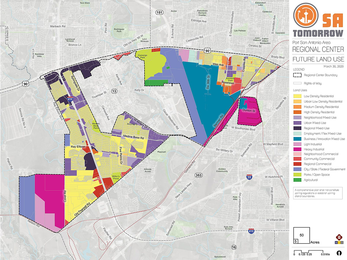
The Port San Antonio Area Regional Center Land Use Plan supports implementation of the SA Tomorrow Comprehensive Plan, Multimodal Transportation Plan, and Sustainability Plan. It also draws on recommendations from the SA Corridors Strategic Framework Plan and implements the Vision, Goals, and Plan Framework for the Port San Antonio Area. The Future Land Use Plan encourages growth and increased density at various scales in mixed-use centers and focus areas and along key transit and community corridors while respecting the unique character of the Regional Center as an area that is military friendly and evolving as an innovation hub that focuses on science, technology, and education.
The following sections describe the general future land use patterns of the Port San Antonio Area. Recommendations for implementing the land use plan follow, and the full catalogue of land use categories (including descriptions and allowable zoning districts) adopted in the Unified Development Code Chapter 35 (UDC) are found at the bottom of the page.
Residential Areas
Low Density Residential
Residential areas of the Port San Antonio Area Regional center consist predominantly of single-family detached housing, with significantly less inventory of other housing product types available. Many of the existing single-family residential areas are older neighborhoods developed decades ago to house the many military and civilian families employed by and linked to Kelly Air Force Base such as Thompson Neighborhood north of Port San Antonio and several areas west and southwest of Lackland Air Force Base. In the last 20 years, some infill developments and newer homes were constructed on the few vacant parcels in the northeasterly side of the Regional Center. The majority of new single-family detached subdivisions of densities comparable to the existing housing stock in this region are being constructed in undeveloped pockets surrounding the current residential subdivisions on undeveloped land that has recently been platted in the southwesterly and westerly portions of the Regional Center. Most of the older and recently developed single-family home neighborhoods are designated low-density residential or urban low-density residential, with most of the neighborhoods zoned R-4, R-5, or R-6.
The Future Land Use Plan for the Port San Antonio Area designates the majority of existing single-family residential neighborhoods as Low Density Residential in order to protect the character of established communities. Some exceptions apply for existing or planned residential communities that are of a higher density within the westerly/south-westerly area of the Regional Center. For example, existing and planned subdivisions around the intersection of Five Palms Drive and Ray Ellison Boulevard are designated Urban Low Density Residential to accommodate attached single-family residential units. Another location with the Urban Low Density Residential designation is on the southwest corner of Medina Base Road and Holm Road, anticipated for subsequent phases of the existing residential development located east of Yucca Valley and south of Medina Base road.
Several small areas and key corridors north and northeast of Port San Antonio are also designated as Urban Low Density Residential to help serve as transitional buffers between established residential areas of Thompson Neighborhood and anticipated mixed-use development along 36th street and higher intensity non-residential uses at the Port.
Medium and High Density Residential
In addition to the predominant stock of single-family detached homes within the Regional Center area, other notable residential housing available in the study area includes:
- The Blue Skies of Texas senior living facility located west of Loop 410;
- The Freedom Hills Ranch Apartments located off Ray Ellison Boulevard, which includes 252 units varying in size between 738 and 1,193 square feet with 1 to 3 bedrooms;
- Stablewood Farm Apartments, which was part of the Stablewood Farms Tax Increment Reinvestment Zone;
- A mobile home park east of Loop 410, just south of US-90;
- A mobile home park west of General McMullen Drive, just north of Weir Avenue; and
- A number of garden style apartments located off General McMullen Drive, Barclay Street, Military Drive, and Medina Base Road, to name a few.
There are some duplexes scattered throughout the plan area and integrated into the surrounding neighborhoods.
Most existing multi-family properties are two or three stories in height and designated as Medium Density Residential. There are several such multi-family apartment complexes in the Thompson Neighborhood, many of which are older buildings constructed several decades ago. The southwestern portion of the Regional Center has newer market-rate medium density apartment complexes. Other Medium Density Residential designations are generally proposed adjacent to major roadways and arterials to serve as a buffer and transition between the non-residential uses and surrounding low density residential uses.
Lastly, High Density Residential is designated in two areas:
- The 252 unit Freedom Hills Ranch apartment complex located on the southeast corner of Ray Ellison Drive and Loop 410 (the only property in the western area of the Regional Center to have the High Density Residential designation); and
- Properties around the intersection of General McMullen Drive and Billy Mitchell Boulevard, which accommodates existing apartment complexes and encourages continued use of the properties for higher density housing.
Mixed-Use Centers and Corridors
The Future Land Use Plan for the Port San Antonio Area Regional Center encourages increased density with a mix of uses to create more active corridors, particularly along key roadways in the plan area. Mixed-use designated areas can serve as appropriate transitions to adjacent neighborhoods while creating environments that can spur local economic vitality. Mixed-use areas prioritize pedestrian and bicycle access, the creation of great public spaces, and should support various levels of transit service based on density and expected level of activity. Mixed-use designations build in flexibility for future development that is responsive to changing economic conditions and market preferences.
The Port San Antonio Area Regional Center Land Use Plan primarily designates mixed-use areas adjacent to major roadways throughout the Regional Center, including: Loop 410 Frontage Road, US-90, Military Drive, Old Pearsall Road, General McMullen Drive, Valley Hi Drive, Medina Base Road, Ray Ellison Boulevard, Cupples Road, and Frio City Road. Mixed-use designations allow existing commercial uses to continue while also adding flexibility for potential new commercial, office, and residential development near important arterial roads and transit corridors. Around the US-90 and Loop 410 interchange, the properties are designated Regional Mixed-use, which is the most intense of the mixed-use land use categories. Less intense mixed-use designations of Urban Mixed-use and Neighborhood Mixed-use are applied throughout other areas of the Regional Center to assure that future development could be more dense but also compatible with existing land uses.
Regional Mixed-Use
The Regional Mixed-Use areas are intended to be centers with the highest intensity of uses and activity, serving nearby neighborhoods and regional interests alike. The residential components of projects in these areas are typically high density, incorporating first floor retail and commercial uses. A Regional Mixed-Use area is intended to serve as a hub for transportation and mobility, and as a value reference point for surrounding properties and future development. There are four areas in the Regional Center with the Regional Mixed-use designation – along the US-90 and Loop 410 interchange, at the existing Blue Sky Towers further south and located west of Loop 410, immediately south of the Walmart Supercenter located on the southwest corner of the intersection of Loop 410 and Ray Ellison Boulevard, and east of Loop 410, immediately adjacent to the Freedom Hills Ranch Apartments. These areas are the highest intensity mixed-use areas, intended to host the most people living, working, and visiting/recreating.
Urban Mixed-Use
Urban Mixed-Use integrates residential and commercial uses, creating walkable places with access to transit and a variety of active uses throughout the day. Properties located southwest of Lackland Air Force Base and fronting Military Drive are classified as Urban Mixed-Use, as are those between Old Pearsall Road, Military Drive, and Holm Road. Properties fronting Loop 410 and Valley Hi Drive are designated Urban Mixed-Use as well due to existing non-residential uses such as retail and office. The Urban Mixed-Use designation is applied in several different key locations within the Regional Center to create opportunities for new residential and commercial uses to be established along these corridor areas. Smaller areas with the Urban Mixed-Use designation can also be found along General McMullen Drive, Medina Base Road, and Ray Ellison Boulevard.
Neighborhood Mixed-Use
Neighborhood Mixed-Use is designated primarily along one major stretch in the northeasterly area of the Port San Antonio Area Regional Center - Cupples Road. Beyond that, there are small pockets of the Neighborhood Mixed-Use designation applied as transitional buffer areas near existing low density housing. The density and intensity for Neighborhood Mixed-Use is lower than in Urban or Regional Mixed-Use, and it allows small scale office, commercial, institutional uses at a neighborhood scale to maintain compatibility with residential use. Mixed-use buildings with residential units above the first floor are allowed within this designation. These areas generally have smaller buildings and a lower level of activity, amenities, and transit service. The focus is on service to immediately adjacent neighborhoods, providing walkable areas at a scale that complements surrounding neighborhood development. This classification also serves as a transition between neighborhoods and higher intensity uses.
An example of the Neighborhood Mixed-Use designation serving as a transition area is found east of 36th Street south of US-90. The properties immediately abutting 36th Street are designated Employment/Flex Mixed-Use. Immediately to the east, between El Jardin Road and SW 35th Street, the properties are designated Neighborhood Mixed-Use to serve as a transitional buffer to properties east of SW 35th Street designated Urban Low Density Residential. The Neighborhood Mixed-Use designation in this specific situation encourages smaller buildings with fewer people, supporting lower intensities compared to uses allowed in the Employment/Flex Mixed-Use area along 36th Street, which serves as one of the main entries to Port San Antonio.
Commercial Areas
Commercial areas of the Port San Antonio Area are classified as either Regional Commercial or Community Commercial, with the exception of one parcel being designated as Neighborhood Commercial, located on the southwest corner of Thompson Place and Imperial Boulevard. These areas are designated for purely commercial uses, including existing and potential offices, professional services, and convenient retail and services that are intended to support the adjacent residential uses.
Regional Commercial areas are found along Loop 410, particularly at the northeast and northwest corners of where Loop 410 intersects with Old Pearsall Road, near the Ray Ellison intersection along Loop 410, and the Medina Base Road intersection along Loop 410. It is also designated for a few parcels off US-90, and for commercial areas along General McMullen Drive immediately south of the US-90. These areas accommodate larger-scale commercial projects that generate higher traffic demand and require larger lot sizes.
Community Commercial is designated for areas allowing strictly commercial uses, but with less intensity of use and traffic generation than Regional Commercial areas. The areas with a Community Commercial designation include properties just south of US-90 near the 9/11 Memorial, along Cupples Road near the Thompson Place and General Hudnell intersections, east of Miller’s Pond Park, the intersection of General McMullen Drive and Roselawn Road, the southeast corner of Medina Base Road and Ray Ellison Boulevard, and the northeast corner of Old Pearsall Road and Covel Road.
Neighborhood Commercial is designated for lower intensity commercial uses such as small-scale retail or offices that support adjacent residential uses. Neighborhood Commercial uses should be located within walking distance of neighborhood residential areas. Within the plan area, the single parcel with a Neighborhood Commercial designation is located at the southwest corner of Thompson Place and Imperial Boulevard, to limit the intensity of potential future commercial uses that could be established within the residential neighborhood.
Employment Areas
Land designated as mixed-use or commercial will support a variety of businesses and employment opportunities. However, continued redevelopment of Port San Antonio will have an especially significant impact on employment in the area. Port San Antonio is owned by the Port Authority of San Antonio, which is a public entity created to redevelop the former Kelly Air Force Base. The majority of land owned by the Port Authority of San Antonio is designated as Business/Innovation Mixed-Use. Cybersecurity, technological learning centers and/or campuses, aerospace and manufacturing, and research/development institutions are appropriate for these spaces. The Business/Innovation Mixed-Use designation also accommodates and provides flexibility for the Port Authority’s plans to redevelop the area as a destination employment center that also includes residential and commercial uses. Port San Antonio has renovated former living quarters into apartment units and townhomes that are available for rent. However, Port San Antonio continues prioritizing employment uses over residential or mixed-use opportunities at this time. As Port San Antonio continues to redevelop and grow, it should consider ways to balance housing and employment to create an attractive and vibrant environment that is a highly desirable place to both work and live.
St. Philip’s southwest campus, which is immediately adjacent to the East Kelly Railport is also designated as Business/Innovation Mixed-Use to provide the campus flexibility for future development to potentially include office, industrial arts workshops, high tech fabrication, processing and assembling, and other ancillary uses on the campus that complement the college’s disciplines and curriculum.
Land designated as Employment/Flex Mixed-Use allows a broad range of permitted uses, so that light industrial, commercial and residential uses can be compatibly integrated in small to mid-scale projects. This allows adaptive re-use of older industrial or tech flex properties for creative work spaces, cottage industrial or fabrication uses, and residential uses including live-work lofts with apartments located above work spaces. Property along 36th Street south of US-90 is designated as Employment/Flex Mixed-Use, including land that is currently undeveloped, as well as existing businesses adjacent to 36th Street, such as a fiber-glass manufacturing company, an electrical contractor business, a cabinet making business, and a light fabrication business, to name a few.
Industrial
Two important areas in the Regional Center are designated as Heavy Industrial to continue supporting existing uses and the industrial workforce. The areas surrounding the rail lines on the eastern side of the Regional Center are designated Heavy Industrial, including the area known as East Kelly Railport, which is part of the former Kelly Air Field currently being redeveloped by the Port Authority of San Antonio. The Covel Gardens Landfill on the far western side of the Regional Center is also designated as Heavy Industrial to support the need for a local landfill that can expand to accommodate future growth.
Properties east of Lackland Runway and east of Growdon Road, just south of US-90 are designated Light Industrial. This serves as a transition between the runway and the properties closer to 36th Street, which are designated Employment/Flex Mixed-Use.
Properties south of the Covel Gardens Landfill, located on the western side of the Regional Center, are designated Light Industrial, which will accommodate existing business operations and potential future operations that would be compatible with the more intense landfill operation. The Light Industrial designation also serves as a transition between the heavier industrial designation of the landfill and uses beyond the City limits, south of Nelson Road.
Parks and Open Space
Properties designated as Parks and Open Spaces serve recreational and environmental purposes for the Port San Antonio Area Regional Center. Uses include trails, city parks, recreational fields, and riparian areas. Some properties within this plan area designated as Parks/Open Space include: Camargo Park, Miller’s Pond Park, Medina Base Park, Kennedy Park, Kelly Area Park, and Stablewood Farms Park.
Recommendation #1
Preserve and celebrate existing neighborhoods.There are several neighborhoods in the Port San Antonio Area that were developed during an important part of San Antonio’s urban history, and the desire of this community is to preserve the density levels and cohesiveness of these neighborhoods. Home ownership is a priority for these neighborhood areas, and, therefore, single-family residences, complemented by commercial development along corridors, should be the common development form.
Where nonresidential uses are found near residential neighborhoods, the density should gradually decrease from the higher intensity of uses and development. Transitional uses should be employed to minimize the impact of nonresidential traffic, noise, light and activity on neighborhoods. Transitional uses are those land use categories that are slightly more intense than that of the neighborhood, but slightly less intense than that of the adjacent nonresidential area.
Neighborhoods in this plan area should be connected to parks and open spaces, as well as commercial areas that provide services to residents. Beyond the existing network of roads, these connections could be via trails, park land or improved sidewalks. More parks, trails and open spaces, or enhancements to the existing parks and trails, are needed in this plan area.
Recommendation #2
Focus areas and mixed-use corridors should be characterized by a mixture of compatible uses, at a scale that complements surrounding uses and development.Although Port San Antonio and Lackland Air Force Base are two major anchors and institutions for this project area, they are special purpose areas that do not function as major regional destinations in terms of retail, commerce, recreation, and services. However, they do provide significant employment, serving the entire San Antonio community. Port San Antonio can more successfully evolve into a regional destination and fulfill its vision as one of the nation’s leading centers of cybersecurity with a greater focus on development and attraction of amenities beyond just employment opportunities. For this reason, the major entrance corridors to the two areas should be characterized by a mixture of uses that can serve the Base and Port San Antonio. For example, the area along 36th Street just south of U.S. Highway 90 is designated Employment/Flex Mixed-use to allow for a mixture of uses in an area that is anticipated to be one of the primary routes into Port San Antonio. The Port San Antonio property along Highway 371/General Hudnell Drive is designated as Business/Innovation Mixed-use, which is a more intense mixed-use designation as it is located closer to the anticipated Innovation Hub, an area planned to be the most intense activity center for Port San Antonio.
Improved wayfinding and definition of place within the plan area is crucial in creating an attractive activity center that appeals to residents, visitors, and employees that commute to the Regional Center. Because of the size and levels of activity associated with Lackland Air Force Base and Port San Antonio, it is difficult to identify a single center of activity to which this entire plan area is oriented. Several activity centers have therefore been identified within the plan area, with recommendations and strategies intended to improve the connections among the various parts of the plan area, and to ensure access of the entire community to employment, commerce, recreation, and services.
Recommendation #3
Encourage more diversity of housing options in the Port San Antonio Area Regional Center.Although the historic patterns of use for this plan area were limited to single-family detached homes and garden-style apartments, changes and preferences in housing types have created a need to diversify the types of housing provided in the Port San Antonio Area Regional Center. This could include townhouses, bungalow courts, and semi-detached houses, as well as higher density multi-family where appropriate.
Recommendation #4
Concentrate density of development and intensity of activity at key intersections in the plan area.High traffic intersections that can accommodate regional-scale development should be positioned as centers for commerce and services. Centers are important for aggregating activity at key crossroads, reinforcing the identity of the corridors, and providing access to services and destinations within the plan area. Higher density centers are appropriate along US-90 and Loop 410.
Future Land Use Categories
As described above, the Port San Antonio Area Regional Center includes a range of land use designations that represent the unique character of the area, while encouraging and supporting development patterns that reflect the goals of the SA Tomorrow Comprehensive Plan and the preferences of the Port San Antonio Area community. Listed below is the full list of land use categories adopted by City Council into the Unified Development Code (UDC), Chapter 35, on October 11, 2018. Each category listed includes a description, general guidance on where the land use designation is most appropriate, and a list of allowable zoning districts.
Residential Estate
Residential Estate includes large lot single-family detached houses on individual estate-sized lots or in conservation subdivisions. This form of development should be located away from major arterials, and can include certain nonresidential uses such as schools, places of worship, and parks that are centrally located for convenient neighborhood access. Permitted zoning districts: FR, R-20, RE, and RP.
Typical densities in this land use category would be up to 2 dwelling units per acre.
Low Density Residential
Low Density Residential includes single-family detached houses on individual lots, including manufactured and modular homes. This form of development should not typically be located adjacent to major arterials. This land use category can include certain nonresidential uses such as schools, places of worship, and parks that are centrally located for convenient neighborhood access. Permitted zoning districts: R-4, R-5, R-6, NP-8, NP-10, and NP-15.
Typical densities in this land use category would range from 3 to 12 dwelling units per acre.
IDZ and PUD may be considered consistent with this land use category, provided the permitted uses included on the zoning site plan and zoning ordinance are consistent with the uses and densities outlined above.
Urban Low Density Residential
Urban Low Density Residential includes a range of housing types including single-family attached and detached houses on individual lots, small lot residences, duplexes, triplexes, fourplexes, cottage homes, manufactured homes, low-rise garden- style apartments, and manufactured home parks. This land use category may also accommodate small scale retail and service uses that are intended to support the adjacent residential uses. Other nonresidential uses, including, but not limited to, schools, places of worship, and parks are appropriate within these areas and should be centrally located to provide easy accessibility. Permitted zoning districts: R-3, R-4, R-5, R-6, RM-5, RM-6, MF-18, MH, MHC, MHP, and NC.
Typical densities in this land use category would range from 7 to 18 dwelling units per acre.
IDZ, PUD, MXD, and TOD may be considered consistent with this land use category, provided the permitted uses included on the zoning site plan and zoning ordinance are consistent with the uses and densities outlined above.
Medium Density Residential
Medium Density Residential accommodates a range of housing types including single-family attached and detached houses on individual lots, manufactured and modular homes, duplexes, triplexes, fourplexes, and low-rise, garden-style apartments with more than four (4) dwelling units per building. Cottage homes and very small lot single-family houses are also appropriate within this land use category. Higher density multi-family uses, where practical, should be located in proximity to transit facilities. Certain nonresidential uses, including, but not limited to, schools, places of worship, and parks are appropriate within these areas and should be centrally located to provide easy accessibility. Permitted zoning districts: R-3, R-4, RM-4, RM-5, RM-6, MF-18, MF-25, MF-33, MH, MHC, and MHP.
Typical densities in this land use category would range from 13 to 33 dwelling units per acre.
IDZ, PUD, MXD, and TOD may be considered consistent with this land use category, provided the permitted uses included on the zoning site plan and zoning ordinance are consistent with the uses and densities outlined above.
High Density Residential
High Density Residential includes low-rise to mid-rise buildings with four (4) or more dwelling units in each. High density residential provides for compact development including apartments, condominiums, and assisted living facilities. This form of development is typically located along or near major arterials or collectors. High density multi-family uses should be located in close proximity to transit facilities. Certain nonresidential uses, including, but not limited to schools, places of worship, and parks are appropriate within these areas and should be centrally located to provide easy accessibility. This classification may be used as a transitional buffer between lower density residential uses and nonresidential uses. High density residential uses should be located in a manner that does not route traffic through lower-density residential uses. Permitted zoning districts: RM-4, MF-25, MF-33, MF-40, MF-50, MF-65, MH, MHC, and MHP.
Typical densities in this land use category would range from 25 to 50 dwelling units per acre.
IDZ, PUD, MXD, and TOD may be considered consistent with this land use category, provided the permitted uses included on the zoning site plan and zoning ordinance are consistent with the uses and densities outlined above.
Neighborhood Commercial
Neighborhood Commercial includes smaller intensity commercial uses such as small-scale retail or offices, professional services, and convenience retail and services that are intended to support the adjacent residential uses. Neighborhood commercial uses should be located within walking distance of neighborhood residential areas. Special consideration should be given to pedestrian and bicycle facilities that connect neighborhoods to commercial nodes. Permitted zoning districts: O-1, NC, and C-1.
IDZ, PUD, MXD, TOD, and MPCD may be considered consistent with this land use category, provided the permitted uses included on the zoning site plan and zoning ordinance are consistent with the uses and densities outlined above.
Community Commercial
Community Commercial includes offices, professional services, and retail uses that are accessible to bicyclists and pedestrians and linked to transit facilities. This form of development should be located in proximity to major intersections or where an existing commercial area has been established. Community commercial uses are intended to support multiple neighborhoods, have a larger market draw than neighborhood commercial uses, and attract patrons from the neighboring residential areas. All off-street parking and loading areas adjacent to residential uses should include landscape buffers, lighting and signage controls. Examples of community commercial uses include, but are not limited to, cafes, offices, restaurants, beauty parlors, neighborhood groceries or markets, shoe repair shops and medical clinics. Permitted zoning districts: O-1.5, NC, C-1, and C-2.
IDZ, PUD, MXD, TOD, and MPCD may be considered consistent with this land use category, provided the permitted uses included on the zoning site plan and zoning ordinance are consistent with the uses and densities outlined above.
Regional Commercial
Regional Commercial includes high intensity uses that draw customers from both adjacent communities as well as the larger metropolitan region. Regional commercial uses are typically located in general proximity to nodes along expressways or major arterial roadways and incorporate high-capacity transit facilities. Regional Commercial uses should incorporate well-defined entrances, shared internal circulation, limited curb cuts to expressways and arterial streets, sidewalks and shade trees in parking lots, landscaping between the parking lots and roadways, and well- designed monument signage. Examples of regional commercial uses include, but are not limited to, movie theaters, plant nurseries, automotive repair shops, fitness centers, home improvement centers, hotels and motels, mid- to high-rise office buildings, and automobile dealerships. Permitted zoning districts: O-1.5, O-2, C- 2, C-3, L, and BP.
IDZ, PUD, MXD, TOD and MPCD may be considered consistent with this land use category, provided the permitted uses included on the zoning site plan and zoning ordinance are consistent with the uses and densities outlined above.
Neighborhood Mixed-Use
Neighborhood Mixed-Use contains a mix of residential, commercial, and institutional uses at a neighborhood scale. Within mixed-use buildings, residential units located above first floor are encouraged. Typical first floor uses include, but are not limited to, small office spaces, professional services, and small-scale retail establishments and restaurants. The mix of uses may be vertically or horizontally distributed, and there is no requirement that a single building contain more than one use. Live/work housing options are permissible in Neighborhood Mixed-Use area to ensure access to housing options and services within close proximity for the local workforce. Where practical, buildings are situated close to the public right-of-way, and parking is located behind buildings. Parking requirements may be minimized using a variety of creative methods, such as shared or cooperative parking agreements, to maximize land available for housing and community services. Pedestrian spaces are encouraged to include lighting and signage, and streetscaping should be scaled for pedestrians, cyclists, and vehicles. Properties classified as Neighborhood Mixed-Use should be located in close proximity to transit facilities. Permitted zoning districts: RM-4, RM-5, RM-6, MF-18, O-1, NC, C-1, MH, MHC, MHP, FBZD, AE-1, and AE-2.
IDZ, PUD, MXD, TOD and MPCD may be considered consistent with this land use category, provided the permitted uses included on the zoning site plan and zoning ordinance are consistent with the uses and densities outlined above.
Urban Mixed-Use
Urban Mixed-Use contains a mix of residential, commercial, and institutional uses at a medium level of intensity. Urban Mixed-Use development is typically larger-scale than Neighborhood Mixed-Use and smaller-scale than Regional Mixed-Use, although many of the allowable uses could be the same in all three categories. Building footprints may be block-scale, but could be smaller depending on block configuration and overall development density. Typical first floor uses include, but are not limited to, professional services, offices, institutional uses, restaurants, and retail including grocery stores. The mix of uses may be vertically or horizontally distributed, and there is no requirement that a single building contain more than one use. Live/work housing options are permissible in Urban Mixed-Use areas to ensure access to housing options and services within close proximity for the local workforce. Structured parking is encouraged in Urban Mixed-Use category, but is not required. Parking requirements may be satisfied through shared or cooperative parking agreements, which could include off-site garages or lots. The Urban Mixed-Use category should be located in proximity to transit facilities. Permitted zoning districts: RM-4, RM-5, RM-6, MF-18, MF-25, MF-33, MF-40, O-1, O-1.5, C-1, C-2, MH, MHP, MHC, FBZD, AE-1, AE-2, AE-3, and AE-4.
IDZ, PUD, MXD, TOD and MPCD may be considered consistent with this land use category, provided the permitted uses included on the zoning site plan and zoning ordinance are consistent with the uses and densities outlined above.
Regional Mixed-Use
Regional Mixed-use contains residential, commercial and institutional uses at high densities. Regional Mixed-Use developments are typically located within regional centers and in close proximity to transit facilities, where mid-rise to high-rise buildings would be appropriate. Typical lower floor uses include, but are not limited to, offices, professional services, institutional uses, restaurants, and retail including grocery stores. The mix of uses may be vertically or horizontally distributed, and there is no requirement that a single building contain more than one use. Live/work housing options are permissible in Regional Mixed-Use areas to ensure access to housing options and services within close proximity for the local workforce. Where feasible, development is ideally built at the block scale, with minimum building setbacks. Parking requirements may be satisfied through shared or cooperative parking agreements, which can include off-site garages or lots. If parking requirements are satisfied on-site, structured parking is encouraged. Pedestrian spaces are encouraged to be generous in width and lighting, with streetscaping and signage scaled to pedestrians. Regional Mixed-Use projects encourage incorporation of transit facilities into development. Permitted zoning districts: MF-33, MF-40, MF-50, MF-65, O-1.5, O-2, C-2, C-3, D, ED, FBZD, AE-1, AE-2, AE-3, and AE-4.
IDZ, PUD, MXD, TOD and MPCD may be considered consistent with this land use category, provided the permitted uses included on the zoning site plan and zoning ordinance are consistent with the uses and densities outlined above.
Employment/Flex Mixed-Use
Employment/Flex Mixed-Use provides a flexible live/work environment with an urban mix of residential and light service industrial uses. Uses include smaller-scale office, retail, art studio warehouses, art-oriented fabrication, creative businesses and work spaces, and cottage industrial and fabrication uses. Adaptive uses of vacant or underutilized structures are encouraged to provide residential urban infill and appropriate employment opportunities within or in close proximity to neighborhoods. Buildings have a smaller footprint and can closely resemble campus-like development across multiple sites or with several multi-functioning buildings on one site. Permitted zoning districts: RM-4, MF-18, MF-25, MF-33, O-1, O-1.5, C-1, C-2, L, AE-1, AE-2, AE-3, and AE-4.
IDZ, PUD, MXD, TOD and MPCD may be considered consistent with this land use category, provided the permitted uses included on the zoning site plan and zoning ordinance are consistent with the uses and densities outlined above.
Business/Innovation Mixed-Use
Business/Innovation Mixed-Use accommodates industrial uses with office, commercial, and residential uses, all within a cohesive setting, on a larger scale and within larger footprints than the Employment/Flex Mixed-Use category. Industrial arts workshops, high tech fabrication, processing and assembly, and other industrial uses are permitted, in addition to commercial uses. Vocational training, technological learning centers, medical campuses, and research/development institutions are also appropriate for these spaces. Additional environmental performance standards should be employed for properties designated as Business/Innovation Mixed-Use, such as hours of activity, loading, noise levels and lighting, to ensure that the intensity of the industrially oriented uses is comparable to that of the other non-residential uses. The mix of uses may be either vertically or horizontally distributed. Live/work housing options are permissible in Business/Innovation Mixed-use areas to ensure access to housing options and services within close proximity of business innovation areas for the local-workforce. Business/Innovation mixed-use should incorporate transit and bicycle facilities to serve the training and employment base. Permitted zoning districts: RM-4, MF-18, MF-25, O-1.5, O-2, C-2, C-3, L, I-1, MI-1, BP, AE-1, AE-2, AE-3, and AE-4.
IDZ, PUD, MXD, TOD and MPCD may be considered consistent with this land use category, provided the permitted uses included on the zoning site plan and zoning ordinance are consistent with the uses and densities outlined above.
Light Industrial
Light Industrial includes a mix of manufacturing uses, business park, and limited retail/service uses that serve the industrial uses. Industrial uses should be screened and buffered from adjoining non-industrial uses. Any outside storage should be under a roof and screened from public view. Examples of light industrial uses include drug laboratories, furniture wholesalers, lumberyards, food production, and warehousing. Permitted zoning districts: L, I-1, MI-1, and BP.
IDZ, TOD, and MPCD may be considered consistent with this land use category, provided the permitted uses included on the zoning site plan and zoning ordinance are consistent with the uses and densities outlined above.
Heavy Industrial
Heavy Industrial includes heavy manufacturing, processing and fabricating businesses. Heavy industrial uses shall be concentrated at arterials, expressways, and railroad lines. This category is not compatible with neighborhood-scaled categories or those that permit residential zoning. Heavy Industrial should be separated from non-industrial uses by an allowable land use or a significant buffer. Examples of heavy industrial uses include auto manufacturing, battery manufacturing, and petro chemical bulk storage. Permitted zoning districts: I-1, I-2, MI-1, MI-2, QD, and SGD.
Agricultural
Agricultural includes crop agriculture, ranching, and related agribusiness practices. Single-family detached houses and detached accessory dwelling units are permitted on agricultural and ranch lands at very low densities or in conservation subdivisions that will not interfere with agricultural operations. Limited commercial uses directly serving agricultural and ranching uses, such as farmers markets, nurseries, stables, bed and breakfasts are permitted. To maintain scenic qualities, natural vegetative buffers, deeper setbacks, increased signage control, earthen drainage channels, and more restrictive access management standards are desired along major scenic corridors. Floodplain protection and buffer zones along creeks and rivers are instrumental in retaining rural character. Permitted zoning districts: RP and FR.
Parks/Open Space
Parks/Open Space may include, but is not limited to, large, linear, or unimproved land where conservation is promoted, and development is not encouraged due to the presence of topographic constraints or institutional uses on the site. Parks/Open Space may include utility corridors and public or private land uses that encourage outdoor passive or active recreation. Examples include city owned and/or operated pocket, regional, or linear parks, as well as private parks associated with subdivisions and neighborhood associations.
City/State/Federal Government
City/State/Federal Government includes areas owned and operated by a federal, state, or city agency. Examples may include government offices, public service facilities such as libraries and police stations, military bases, state colleges, and federal courts. This category does not apply to properties owned by a public agency but leased to and operated by another party.
Residential Areas
Low Density Residential
Residential areas of the Port San Antonio Area Regional center consist predominantly of single-family detached housing, with significantly less inventory of other housing product types available. Many of the existing single-family residential areas are older neighborhoods developed decades ago to house the many military and civilian families employed by and linked to Kelly Air Force Base such as Thompson Neighborhood north of Port San Antonio and several areas west and southwest of Lackland Air Force Base. In the last 20 years, some infill developments and newer homes were constructed on the few vacant parcels in the northeasterly side of the Regional Center. The majority of new single-family detached subdivisions of densities comparable to the existing housing stock in this region are being constructed in undeveloped pockets surrounding the current residential subdivisions on undeveloped land that has recently been platted in the southwesterly and westerly portions of the Regional Center. Most of the older and recently developed single-family home neighborhoods are designated low-density residential or urban low-density residential, with most of the neighborhoods zoned R-4, R-5, or R-6.
The Future Land Use Plan for the Port San Antonio Area designates the majority of existing single-family residential neighborhoods as Low Density Residential in order to protect the character of established communities. Some exceptions apply for existing or planned residential communities that are of a higher density within the westerly/south-westerly area of the Regional Center. For example, existing and planned subdivisions around the intersection of Five Palms Drive and Ray Ellison Boulevard are designated Urban Low Density Residential to accommodate attached single-family residential units. Another location with the Urban Low Density Residential designation is on the southwest corner of Medina Base Road and Holm Road, anticipated for subsequent phases of the existing residential development located east of Yucca Valley and south of Medina Base road.
Several small areas and key corridors north and northeast of Port San Antonio are also designated as Urban Low Density Residential to help serve as transitional buffers between established residential areas of Thompson Neighborhood and anticipated mixed-use development along 36th street and higher intensity non-residential uses at the Port.
Medium and High Density Residential
In addition to the predominant stock of single-family detached homes within the Regional Center area, other notable residential housing available in the study area includes:
- The Blue Skies of Texas senior living facility located west of Loop 410;
- The Freedom Hills Ranch Apartments located off Ray Ellison Boulevard, which includes 252 units varying in size between 738 and 1,193 square feet with 1 to 3 bedrooms;
- Stablewood Farm Apartments, which was part of the Stablewood Farms Tax Increment Reinvestment Zone;
- A mobile home park east of Loop 410, just south of US-90;
- A mobile home park west of General McMullen Drive, just north of Weir Avenue; and
- A number of garden style apartments located off General McMullen Drive, Barclay Street, Military Drive, and Medina Base Road, to name a few.
There are some duplexes scattered throughout the plan area and integrated into the surrounding neighborhoods.
Most existing multi-family properties are two or three stories in height and designated as Medium Density Residential. There are several such multi-family apartment complexes in the Thompson Neighborhood, many of which are older buildings constructed several decades ago. The southwestern portion of the Regional Center has newer market-rate medium density apartment complexes. Other Medium Density Residential designations are generally proposed adjacent to major roadways and arterials to serve as a buffer and transition between the non-residential uses and surrounding low density residential uses.
Lastly, High Density Residential is designated in two areas:
- The 252 unit Freedom Hills Ranch apartment complex located on the southeast corner of Ray Ellison Drive and Loop 410 (the only property in the western area of the Regional Center to have the High Density Residential designation); and
- Properties around the intersection of General McMullen Drive and Billy Mitchell Boulevard, which accommodates existing apartment complexes and encourages continued use of the properties for higher density housing.
Mixed-Use Centers and Corridors
The Future Land Use Plan for the Port San Antonio Area Regional Center encourages increased density with a mix of uses to create more active corridors, particularly along key roadways in the plan area. Mixed-use designated areas can serve as appropriate transitions to adjacent neighborhoods while creating environments that can spur local economic vitality. Mixed-use areas prioritize pedestrian and bicycle access, the creation of great public spaces, and should support various levels of transit service based on density and expected level of activity. Mixed-use designations build in flexibility for future development that is responsive to changing economic conditions and market preferences.
The Port San Antonio Area Regional Center Land Use Plan primarily designates mixed-use areas adjacent to major roadways throughout the Regional Center, including: Loop 410 Frontage Road, US-90, Military Drive, Old Pearsall Road, General McMullen Drive, Valley Hi Drive, Medina Base Road, Ray Ellison Boulevard, Cupples Road, and Frio City Road. Mixed-use designations allow existing commercial uses to continue while also adding flexibility for potential new commercial, office, and residential development near important arterial roads and transit corridors. Around the US-90 and Loop 410 interchange, the properties are designated Regional Mixed-use, which is the most intense of the mixed-use land use categories. Less intense mixed-use designations of Urban Mixed-use and Neighborhood Mixed-use are applied throughout other areas of the Regional Center to assure that future development could be more dense but also compatible with existing land uses.
Regional Mixed-Use
The Regional Mixed-Use areas are intended to be centers with the highest intensity of uses and activity, serving nearby neighborhoods and regional interests alike. The residential components of projects in these areas are typically high density, incorporating first floor retail and commercial uses. A Regional Mixed-Use area is intended to serve as a hub for transportation and mobility, and as a value reference point for surrounding properties and future development. There are four areas in the Regional Center with the Regional Mixed-use designation – along the US-90 and Loop 410 interchange, at the existing Blue Sky Towers further south and located west of Loop 410, immediately south of the Walmart Supercenter located on the southwest corner of the intersection of Loop 410 and Ray Ellison Boulevard, and east of Loop 410, immediately adjacent to the Freedom Hills Ranch Apartments. These areas are the highest intensity mixed-use areas, intended to host the most people living, working, and visiting/recreating.
Urban Mixed-Use
Urban Mixed-Use integrates residential and commercial uses, creating walkable places with access to transit and a variety of active uses throughout the day. Properties located southwest of Lackland Air Force Base and fronting Military Drive are classified as Urban Mixed-Use, as are those between Old Pearsall Road, Military Drive, and Holm Road. Properties fronting Loop 410 and Valley Hi Drive are designated Urban Mixed-Use as well due to existing non-residential uses such as retail and office. The Urban Mixed-Use designation is applied in several different key locations within the Regional Center to create opportunities for new residential and commercial uses to be established along these corridor areas. Smaller areas with the Urban Mixed-Use designation can also be found along General McMullen Drive, Medina Base Road, and Ray Ellison Boulevard.
Neighborhood Mixed-Use
Neighborhood Mixed-Use is designated primarily along one major stretch in the northeasterly area of the Port San Antonio Area Regional Center - Cupples Road. Beyond that, there are small pockets of the Neighborhood Mixed-Use designation applied as transitional buffer areas near existing low density housing. The density and intensity for Neighborhood Mixed-Use is lower than in Urban or Regional Mixed-Use, and it allows small scale office, commercial, institutional uses at a neighborhood scale to maintain compatibility with residential use. Mixed-use buildings with residential units above the first floor are allowed within this designation. These areas generally have smaller buildings and a lower level of activity, amenities, and transit service. The focus is on service to immediately adjacent neighborhoods, providing walkable areas at a scale that complements surrounding neighborhood development. This classification also serves as a transition between neighborhoods and higher intensity uses.
An example of the Neighborhood Mixed-Use designation serving as a transition area is found east of 36th Street south of US-90. The properties immediately abutting 36th Street are designated Employment/Flex Mixed-Use. Immediately to the east, between El Jardin Road and SW 35th Street, the properties are designated Neighborhood Mixed-Use to serve as a transitional buffer to properties east of SW 35th Street designated Urban Low Density Residential. The Neighborhood Mixed-Use designation in this specific situation encourages smaller buildings with fewer people, supporting lower intensities compared to uses allowed in the Employment/Flex Mixed-Use area along 36th Street, which serves as one of the main entries to Port San Antonio.
Commercial Areas
Commercial areas of the Port San Antonio Area are classified as either Regional Commercial or Community Commercial, with the exception of one parcel being designated as Neighborhood Commercial, located on the southwest corner of Thompson Place and Imperial Boulevard. These areas are designated for purely commercial uses, including existing and potential offices, professional services, and convenient retail and services that are intended to support the adjacent residential uses.
Regional Commercial areas are found along Loop 410, particularly at the northeast and northwest corners of where Loop 410 intersects with Old Pearsall Road, near the Ray Ellison intersection along Loop 410, and the Medina Base Road intersection along Loop 410. It is also designated for a few parcels off US-90, and for commercial areas along General McMullen Drive immediately south of the US-90. These areas accommodate larger-scale commercial projects that generate higher traffic demand and require larger lot sizes.
Community Commercial is designated for areas allowing strictly commercial uses, but with less intensity of use and traffic generation than Regional Commercial areas. The areas with a Community Commercial designation include properties just south of US-90 near the 9/11 Memorial, along Cupples Road near the Thompson Place and General Hudnell intersections, east of Miller’s Pond Park, the intersection of General McMullen Drive and Roselawn Road, the southeast corner of Medina Base Road and Ray Ellison Boulevard, and the northeast corner of Old Pearsall Road and Covel Road.
Neighborhood Commercial is designated for lower intensity commercial uses such as small-scale retail or offices that support adjacent residential uses. Neighborhood Commercial uses should be located within walking distance of neighborhood residential areas. Within the plan area, the single parcel with a Neighborhood Commercial designation is located at the southwest corner of Thompson Place and Imperial Boulevard, to limit the intensity of potential future commercial uses that could be established within the residential neighborhood.
Employment Areas
Land designated as mixed-use or commercial will support a variety of businesses and employment opportunities. However, continued redevelopment of Port San Antonio will have an especially significant impact on employment in the area. Port San Antonio is owned by the Port Authority of San Antonio, which is a public entity created to redevelop the former Kelly Air Force Base. The majority of land owned by the Port Authority of San Antonio is designated as Business/Innovation Mixed-Use. Cybersecurity, technological learning centers and/or campuses, aerospace and manufacturing, and research/development institutions are appropriate for these spaces. The Business/Innovation Mixed-Use designation also accommodates and provides flexibility for the Port Authority’s plans to redevelop the area as a destination employment center that also includes residential and commercial uses. Port San Antonio has renovated former living quarters into apartment units and townhomes that are available for rent. However, Port San Antonio continues prioritizing employment uses over residential or mixed-use opportunities at this time. As Port San Antonio continues to redevelop and grow, it should consider ways to balance housing and employment to create an attractive and vibrant environment that is a highly desirable place to both work and live.
St. Philip’s southwest campus, which is immediately adjacent to the East Kelly Railport is also designated as Business/Innovation Mixed-Use to provide the campus flexibility for future development to potentially include office, industrial arts workshops, high tech fabrication, processing and assembling, and other ancillary uses on the campus that complement the college’s disciplines and curriculum.
Land designated as Employment/Flex Mixed-Use allows a broad range of permitted uses, so that light industrial, commercial and residential uses can be compatibly integrated in small to mid-scale projects. This allows adaptive re-use of older industrial or tech flex properties for creative work spaces, cottage industrial or fabrication uses, and residential uses including live-work lofts with apartments located above work spaces. Property along 36th Street south of US-90 is designated as Employment/Flex Mixed-Use, including land that is currently undeveloped, as well as existing businesses adjacent to 36th Street, such as a fiber-glass manufacturing company, an electrical contractor business, a cabinet making business, and a light fabrication business, to name a few.
Industrial
Two important areas in the Regional Center are designated as Heavy Industrial to continue supporting existing uses and the industrial workforce. The areas surrounding the rail lines on the eastern side of the Regional Center are designated Heavy Industrial, including the area known as East Kelly Railport, which is part of the former Kelly Air Field currently being redeveloped by the Port Authority of San Antonio. The Covel Gardens Landfill on the far western side of the Regional Center is also designated as Heavy Industrial to support the need for a local landfill that can expand to accommodate future growth.
Properties east of Lackland Runway and east of Growdon Road, just south of US-90 are designated Light Industrial. This serves as a transition between the runway and the properties closer to 36th Street, which are designated Employment/Flex Mixed-Use.
Properties south of the Covel Gardens Landfill, located on the western side of the Regional Center, are designated Light Industrial, which will accommodate existing business operations and potential future operations that would be compatible with the more intense landfill operation. The Light Industrial designation also serves as a transition between the heavier industrial designation of the landfill and uses beyond the City limits, south of Nelson Road.
Parks and Open Space
Properties designated as Parks and Open Spaces serve recreational and environmental purposes for the Port San Antonio Area Regional Center. Uses include trails, city parks, recreational fields, and riparian areas. Some properties within this plan area designated as Parks/Open Space include: Camargo Park, Miller’s Pond Park, Medina Base Park, Kennedy Park, Kelly Area Park, and Stablewood Farms Park.