Plan Framework and Implementation Priorities

The Plan Framework comprises the six main topics of the plan: Land Use, Focus Areas, Mobility, Amenities and Public Spaces, Housing, and Economic Development. Detailed background information, maps, illustrations, and recommendations for each of those topics can be found in their respective sections following this overview. Throughout those sections, numerous important recommendations and strategies are identified for achieving the vision and goals of the plan based on existing conditions analysis; research and best practices case studies; collaboration with other City departments and partner agencies and organizations; and many conversations with the Planning Team and the wider Port San Antonio Area community.
While all the recommendations and strategies in the plan are important, this overview highlights those that are either most critical to achieving the plan vision and goals, are more likely to be funded and implemented in the short-term, build upon other existing or ongoing initiatives, or are a necessary first step to provide a foundation for other projects and investments. These Implementation Priorities are presented in two ways: the list below represents the full range of priorities, while the accompanying Plan Framework Map [ See Figure ##] illustrates all those that can be physically depicted in order to show important overlaps, adjacencies, and mutually supportive relationships. Some Land Use, Housing, Economic Development, and other recommendations and strategies are not easily depicted on the map but are included in the Implementation Priorities list. Together, the Implementation Priorities and Plan Framework Map represent the key strategic concepts and physical improvements that will influence future development of the Port San Antonio Area Regional Center. '
Land Use
Strategy 1.1 (Regulatory and Policy )
In existing neighborhoods, require future redevelopment and changes in property uses to complement existing residences, in terms of density, heights and setbacks.
Strategy 2.4 (Regulatory and Policy)
In Focus Areas, incorporate multi-family development with commercial uses, community services and employment opportunities.
Strategy 3.4 (Regulatory and Policy)
In areas designated as Urban Mixed-Use, ensure that density and intensity complement neighboring properties and do not have a negative impact on the stability of existing neighborhoods.
Focus Areas
Strategy 1.2: (Regulation and Policy / Partnerships / Investment)
Prioritize major amenity and infrastructure improvement projects that support multiple plan recommendations, including those related to mobility, creation of public space, provision of recreation and green spaces, and protection of natural resources.
Strategy 3.2 (Regulatory and Policy)
Develop and implement multi-modal and transit plans throughout the Port San Antonio Area Regional Center, prioritizing projects in the Focus Areas and building upon connectivity opportunities to existing routes for public transit and green trails for pedestrians and bicyclists.
Mobility
Strategy 3.2 (Regulatory and Policy)
Update street design standards to be consistent with SA Tomorrow goals for safety, economic growth, development, and city form and to reflect the relationship between the built environment and the streetscape. Street design standards should consider all levels of interactions with the street including pedestrians, bicyclists, and motorists. Near term priorities identified in the SA Tomorrow Multimodal Transportation Plan of design standard adjustments include:
· Encourage walkability through context sensitive design treatments like minimum sidewalk widths of 6 to 8 feet with 6-foot buffer on main arterials for higher density residential areas, 10 feet for downtown and in locations designated for transit-oriented development;
· Allow midblock crosswalks with required safety features at locations with high pedestrian demand along roadways with high traffic volumes and long crossing distances; and Encourage cycling through design with treatments such as barrier separated facilities on arterials where posted speed limits are above 35 mph.
Amenities and Public Space
Strategy 1.3 (Regulation and Policy / Investment)
Incorporate street trees when reconstructing sidewalks, curbs, and gutters in mixed-use corridors and focus areas. In San Antonio’s climate, shade is important for making walking a comfortable and viable transportation option.
Strategy 4.1 (Investment)
Add or enhance pedestrian crossings along major thoroughfares throughout the Port San Antonio Area. Crossings for SW 36th Street, General McMullen Drive, Cupples Road, Billy Mitchell Boulevard, Medina Base Road, and Old Pearsall Road should be prioritized for there is currently a significant amount of pedestrian activity that will likely continue to increase along these roadways. Crossings in close proximity to schools, libraries, parks and trails should also be prioritized due to higher pedestrian activity to and from these community assets.
Housing
Strategy 1.3 (Regulatory and Policy/Partnerships)
Identify development sites to purchase for future affordable housing development that are in Focus Areas and along mixed-use corridors through the use of a community land trust, and/or through partnership with the San Antonio Housing Authority and other non-profit housing partners.
Strategy 2.1 (Regulatory and Policy)
Encourage higher-density housing and mixed-use development within in Focus Areas identified in the Regional Center Future Land Use Plan.
Economic Development
Strategy 1.4 (Partnerships)
Partner with the San Antonio Economic Development Foundation to reach out to property owners and businesses outside of the Port San Antonio Authority’s control to identify potential sites within the Regional Center that can support the growth of target industries. Help owners of commercial/industrial properties to leverage their proximity to Port San Antonio and Lackland Air Force Base to attract additional employers to the Regional Center.
Strategy 2.1 (Regulatory and Policy, Investments)
Create a mixed-use center around the planned esports arena at the Innovation Hub Focus Area to provide attractions and opportunities for workers, businesses, residents, visitors to interact and cross paths through both formal and informal events and settings. The mixed-use center should be walkable, provide multimodal connections to other areas in Port San Antonio, and create inviting, safe, and comfortable amenities and public spaces that are active 18-hours a day.
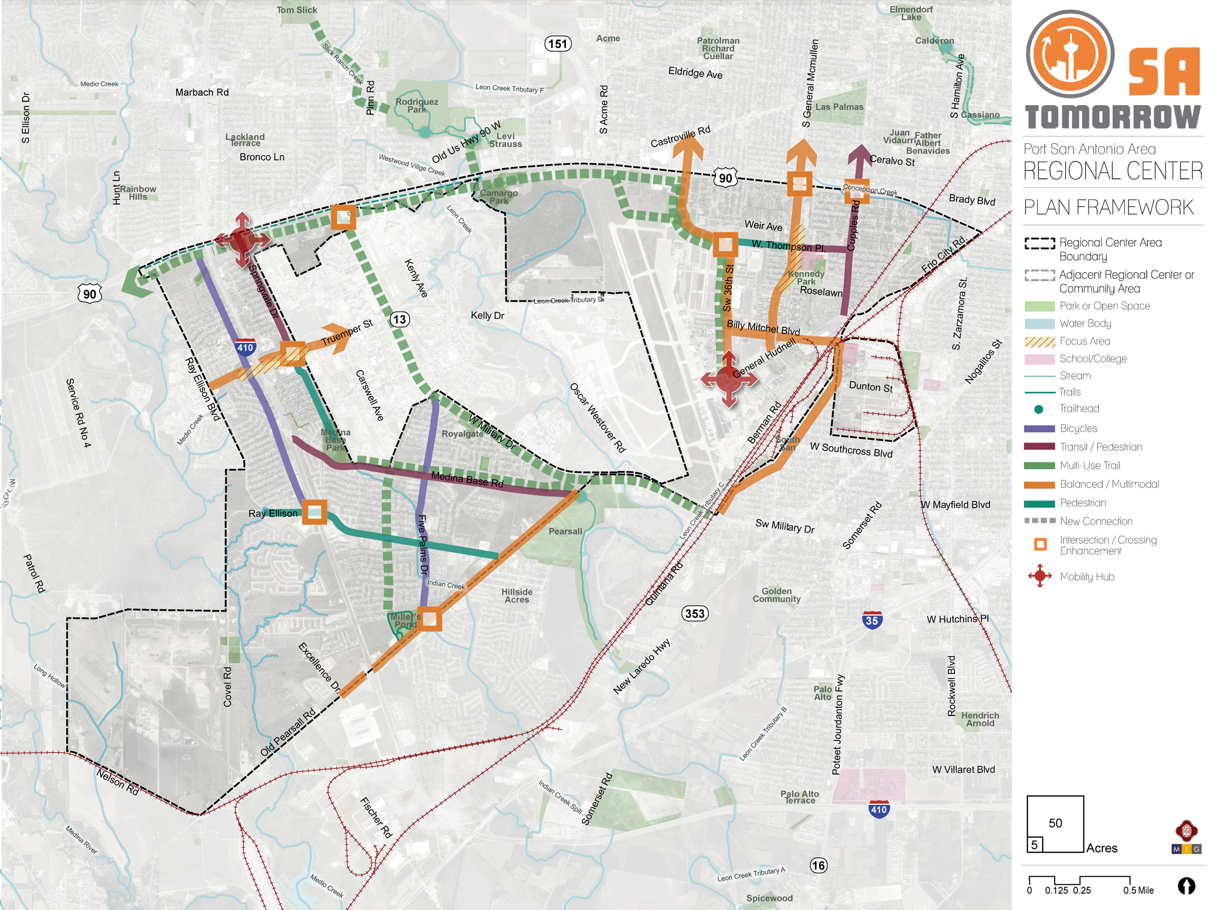
Plan Framework Map Overview
The Plan Framework Map identifies and shows the interrelatedness of key physical concepts and strategies in the plan. These include the focus areas, recommended modal priorities that would then help determine appropriate streetscape improvements, enhanced trail connections, pedestrian crossings, and mobility hubs. These recommended physical improvements and investments are complemented by other supportive plan strategies related to land use, housing, economic development, and providing access to and preserving green space.
Focus Areas
The Port San Antonio Area Regional Center focuses growth and new development in six different Focus Areas, of which two are mixed-use corridors, and where land is available to be developed or redeveloped. The plan framework map is supportive of new trail connection opportunities and mobility routes throughout the plan area to serve not only as recreational opportunities, but also as transportation alternatives to help reduce our reliance on automobiles. In addition to targeting growth within the focus areas, the overall emphasis of the Plan Framework Map for the Port San Antonio Area Regional Center is encouraging modal alternatives that will help minimize traffic congestion in the future and improve connectivity within the Plan Area and to other adjacent neighborhoods, amenities, and businesses. By focusing new development primarily into the six Focus Areas and allowing flexibility in streetscape improvements to reflect modal priorities, future development will occur in a respectful manner that protects and complements the existing neighborhoods.
Non-Vehicular Modal Priorities
Improved pedestrian and bicycle infrastructure are key priorities close to existing neighborhoods, which is reflected with streets denoted in different colors that identify the modal priority corridors. Roadways that were identified as freight or automobile priorities are not included on the Plan Framework Map because those respective roadways have sufficient capacity to serve as such. Furthermore, the overall priority for the Regional Center is improving transportation alternatives that, over time, will make the Port San Antonio Area Regional Center more environmentally sustainable, more equitable and inclusive, and more economically efficient and competitive.
Providing safe pedestrian environments is of high importance for the Port San Antonio Area Regional Center, especially for those areas known to have a significant amount of pedestrian activity close to high traffic areas, such as Valley Hi Drive and S General McMullen Drive. Intersections that warrant crossing enhancements were included in the Mobility Framework Map. Those elevated for inclusion in the overall Framework Map were identified as the most important due to their locations near amenities and/or due to high pedestrian and bicycle activity.
Key corridors will be improved to create pedestrian-friendly environments for residents and businesses as well as to increase safety and comfort for all. With two regional parks located close this Regional Center – Rodriguez Park to the north and Pearsall Park to the south – multi-use trail connection opportunities is another high priority. There is great potential to extend trails throughout the Port San Antonio Area Regional Center, which would enhance existing recreational and park amenities, better connect neighborhoods to trails (thereby increasing trail and park access to a larger population), and improve connectivity and access to important amenities and activity centers throughout the Regional Center.
Mobility Hubs
Lastly, two mobility hubs are prioritized to help make utilization of transportation alternatives more convenient and efficient for residents, workers, and visitors to this Regional Center. The mobility hubs are located purposefully in two different areas of the Regional Center that are anticipated to have an increase in demand for transit. The first mobility hub is located just south of U.S. Highway 90 near the Kel-Lac transit center and park and ride location located north and south of U.S. Highway 90, respectively. Its location near Springvale Drive is intended to complement the community’s vision for pedestrian-oriented streetscape improvements along that corridor south to Truemper Street and the main visitor entrance to JBSA Lackland Air Force Base.
The second mobility hub is located at the intersection of 36th Street and General Hudnell Drive, adjacent to the future esports arena that Port San Antonio is developing within their Innovation Center. This location is also near recent projects that have been completed to improve the pedestrian and bicycle environments.
Establishing the Plan Framework and Recommendations
The Plan Framework includes recommendations and strategies around future land use; focus areas and mixed-use corridors for development or improvement; pedestrian, bicycle, and street improvements; amenities and public space; and priority areas to encourage mixed-use development. All sections of the Plan Framework are presented and briefly described below.
4.1. Land Use: Land Use is a foundation of this plan and all the other sections are intended to respond to and support the designated future land patterns. One of the key goals of implementing the SA Tomorrow Comprehensive Plan is to create a future land use map for the entire city. Through carrying out sub-area plans, such as the Port San Antonio Area Regional Center, the Planning Department will eventually create a detailed future land use map for the entire City of San Antonio.
4.2. Focus Areas: Focus areas are key areas where future investments or other improvements are desired. Mixed-use corridors are a type of focus area where different uses within the corridor are encouraged to generate activity. These mixed-use corridors are key places where there should be future improvements that encourage traveling by different modes other than car, such as walking, biking, and public transportation.
Many of the concepts within this plan are long-term and somewhat abstract. The Focus Areas section aims to take particular project ideas and ask which could really serve as a good example for the types of developments or improvements this area would like to see in the future? While this section has detailed renderings, the specific style choices are more for illustrative purposes to show potential, rather than prescribe certain aspects of a development.
4.3. Mobility: Getting around in the future is, understandably, a key concern for future growth. This section suggests strategies and future improvements to help the area thrive in the future, instead of becoming more and more congested.
4.4. Amenities and Public Space: As the city grows, we need to ensure all communities have things that make them not only nice places to live or work, but also places where people enjoy time outdoors, cultural assets, and basic infrastructure. This section describes desired future projects or policies to make that future a reality.
4.6. Housing: In addressing future growth, there has to be a discussion of housing. This section supports the concepts within the future land use section with specific recommendations for housing in the area.
4.7. Economic Development: Future growth will also depend on economic opportunities within an area. This section describes specific recommendations around how to create an area with a thriving economy.
Public Feedback
The Port San Antonio Area Regional Center Plan Framework was developed through a combination of technical analysis and community input. The Framework illustrates and outlines the overall long-term vision for the Port San Antonio Area Regional Center, including future land use types, priority areas where new development may be focused, recommendations for key mobility improvements, opportunities for additional parks and open space, and other “big moves” or ideas that will shape the future of the area.
At the beginning of the planning process, the project team developed an in-depth study and analysis of the Port San Antonio Area Regional Center to understand the history and development of the area as well as the existing conditions. The Planning Team provided their input on the area’s existing assets, challenges and opportunities to develop a better understanding of the area and the community’s priorities and values. City staff also organized and facilitated additional stakeholder input and public outreach to capture a broad range of Port San Antonio Area Regional Center Area residents’ considerations. Through a series of facilitated work sessions and interactive exercises, the Planning Team provided input and direction that is reflected in the Plan Framework and throughout all sections of the Plan.
Over several months, project staff and the Planning Team worked collaboratively to build upon the Framework to identify the key priorities, improvements, and strategies that will guide growth, development, and investment in the Port San Antonio Area Regional Center. A series of draft recommendations on several topics were developed for stakeholder feedback and are reflected in the Plan.
During the second Planning Team meeting, staff presented on existing conditions and the team discussed assets, challenges and opportunities in the Port San Antonio Area Regional Center Area.
The Plan Framework was then iteratively developed, based on Planning Team conversations, other public input and analysis on each of the plan sections. Multiple planning team meetings were devoted to each of the topics, allowing for initial feedback and then review of draft recommendations. Specific meetings and activities that contributed to the development of each Plan Framework topic are described at the beginning of each of those plan sections.
Land Use
The future land use element of the plan was primarily informed by Planning Team input in Planning Team Meetings #4 and #5, and feedback received from the broader public in the first and second Community Meetings and associated online questionnaires. Initial public input for the draft vision and goals, and other public input related to housing, economic development, and other sections of the plan also informed the future land use element of the plan.
Housing
The housing recommendations were primarily informed by Planning Team input in Planning Team Meetings #6 and #7, and feedback received from the broader public in the first and second Community Meetings and associated online questionnaires. Initial public input for the draft vision and goals, and other public input related to future land use, economic development, and other sections of the plan also informed the housing recommendations and strategies.
Economic Development
In addition to discussing housing in Planning Team Meeting #6, the Planning Team discussed preliminary economic development concepts and strategies. The Project Team presented information on economic development issues and trends in the area. Following the presentation, the Planning Team discussed economic strengths, opportunities, and weaknesses in the area.
In Planning Team Meeting #7, the Planning Team discussed and provided feedback on economic development case studies and conceptual draft economic development recommendations that were based on discussion in the prior meeting. The project team used the results of Planning Team Meetings #6 and #7 to create draft economic development recommendations. These were presented in the second Community Meeting and associated online questionnaire for feedback from the public.
The project team improved the draft housing recommendations and created implementation strategies associated with each recommendation. These were presented for feedback in the second Community Meeting. This feedback was used to confirm and make final improvements to the economic development recommendations and strategies.
Mobility
During the second Community Meeting, the project team gathered input related to mobility. A board with mobility-related questions was displayed at the community meeting for attendees to respond to and provide additional comments and input. Based on input from attendees and input from the Planning Team during two meetings focused on mobility, major corridors were identified on the mobility framework diagram with modal priorities. The Mobility Framework Map was presented to and discussed with the Planning Team to determine appropriate modal priorities for roadways in the Regional Center. Trails, transit routes, bicycle routes, streetscape improvements, pedestrian safety, and traffic congestion were discussed in order to ensure that the Mobility Framework Map reflected the appropriate modal priorities and needs of the community.
Amenities and Public Space
The Planning Team also discussed amenities and public space at Planning Team Meeting #9. Meeting participants were first briefed by City staff on what elements make up a complete neighborhood such as active recreation opportunities, natural features, social spaces, and stormwater management, among other things.
After seeing examples of the elements that create complete neighborhoods, Planning Team members discussed which elements were most critical and should be prioritized to help achieve the vision and goals of the Port San Antonio Area Regional Center. After the presentation on complete neighborhoods, the team broke out into two groups for a mapping exercise to identify areas for amenities and pedestrian improvements, followed by a review of the exercise results.